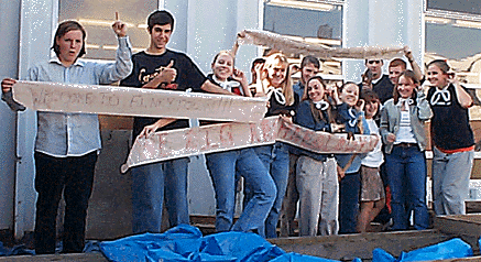
Ada Brinkman, Dianna Czernuszka, Reid Davenport, Andrew
Eaton, Ian Fullerton, Matthew Lauranzano, Andrea Lohnes, Meaghan
Oneil, Jeffrey Oullette, Christine Sciola, Tara Talbot, Alaina
Walsh, and James Bower
Primary Research through the History of Beverly
October 23, 2000
Contents
Introduction
Archaeological Site
Location of a Site
Gridding an Archaeological Site
Excavating an Archaeological Site
Bones
Artifacts
Tools Commonly found at a Site
Pottery
Firing Point Chart
Glaze Chart
Research (Dating)
Radiocarbon Dating
Potassium Argon Dating
Dendrochronology
Pipestem Dating
Palynology
Stratigraphy
Seriation
Introduction
Archaeology is a branch of Anthropology.
Anthropology is the study of man in its broadest sense. Archaeology
is the study of mans past. Archaeologists accomplish heir task
mainly through excavation. Excavation is the process of finding
sites that may contain artifacts. Artifacts are relics of the
past. They are anything created or influenced by man. Once an
Archaeologist believes he has found a site possibly containing
artifacts, he will begin excavating the site. There are many
steps and procedures that have to be followed in order to excavate
a sight professionally.
Once an artifact is found it has to be identified,
labeled, and cataloged. There is three main categories that
the artifacts fall under; pottery, bones and stone artifacts.
Each of those categories is broken down further. An archeologist
then uses artifacts that have been found to make a reconstruction
the way people lived during that time period.
Archaeologists use two types of dating,
relative and absolute. Relative dating is used to get an idea
of when events took place or when certain items were made to
put a more exact data on the artifact. Absolute dating is done
later in the lab once everything is excavated. Different forms
of absolute dating are radiocarbon and potassium argon dating.
Examples of relative dating are Dendrochronology and palynology.
Archaeological Site
Location of a Site
Finding a location is the most important
way to begin and archaeological dig. Many sites are fairly easy
to find because there are monumental. The Pyramids of Giza in
Egypt, Pompeii, or an old house are all obvious sites for excavation.
There are also archaeological sites that are not so clearly
visible. These sites are sometimes submerged in water, or covered
in dense vegetation. Many sites are buried underground and are
not discovered until after they are uncovered by events such
as an environmental change like an earthquake or a strong storm
that causes ground erode.
Visible sites may not be apparent to an
amateurs eye. An experienced trained eye if an archaeologist
will spot small soil erosion or a certain pattern in vegetation
growth that is different in comparison to the average field.
What may look like rubble of an old building could be the foundation
of an old building perfect for an archaeological dig.
After discovering a site, important steps
must be followed in order to ensure that a site is kept in order.
First, an archaeological survey must be done. This is an extensive
walking tour of an area of land in search of any surface artifacts,
of visible sign of human influence. The land terrain and location
area are also closely observed. Archaeologists search for mounds
of gray soil such as animal burrows; and some of these mounds
can reveal artifacts. "The key to an effective archaeological
dig lies in carefully designing the research before one sets
out to use techniques that estimate the probable density of
archaeological sites in the region"
A more intensive survey requires the archaeologists
or researcher to interview local inhabitants (if there are any),
landowners, and to review documents regarding the site. Many
areas of land are known for historical occurrences, these are
obvious sites for archaeological study. There are geographic
areas that are known for being heavily influenced by humans,
which make them primary subjects for excavation; Crimea is one
of these areas. Crimea has an actual palimpsest of inhabitants
placed on a peninsula in the Black Sea, Crimea has had a diverse
culture living in a small area of 15,000 square miles. Crimmerians
were the first to settle there, until they were overthrown by
the Scythians, who were later known as the Taurians. Greek settlers
interwove with the Taurians allowing trade to become easy and
extensive. By A.D. Crimea had been influenced by Sarmatians,
Germanic Goths, Huns, Khazars, Pechenegs, Polovtsians, Slavs,
and Mongols. Crimea would be an example of a good site for excavation
of subterranean artifacts.
Subsurface detection methods are also highly
effective. Hot air balloons, x-rays, and sonic detectors can
all be used to map subterranean features and hidden chambers,
which may not be visible from the ground. Satellite sensory
known as LANDSAT CAN also help in the search for hidden geographic
features. From the ground, a seismograph can detect shockwaves
in the earth. Artifacts buried beneath the ground will conduct
shockwaves faster than the surrounding ash. A ground-penetrating
radar can determine the stratigraphy of an area. Both of these
methods are accurate, however they are very expensive.
Ground surface is not the only place archaeologists
look to find artifacts. The ocean is littered with artifacts
from shipwrecks and items that rest o the ocean floor. Subsurface
detection methods are very useful in determining what lies beneath
the oceans surface, eliminating the need for a diver while searching
for artifacts. This technology is being used extensively torward
the study of the Titanic, as along with many other shipwrecks.
The surrounding waters of the Greek Isles are rich with artifacts
from the ancient Greek and ROMAN Civilizations. Subsurface detection
is carefully used while searching these isles.4
A Geographic Information System (GIS) is
a computer-aided system, that collects, stores, and presents
a retrieval analysis of all spatial data. Accurate mapping,
surface collection, and subsurface investigation using electronic
detection methods can give an archaeologist large amounts of
information before they devote money and time into an archaeological
dig. "Observation is the key to finding archaeological sites
and to study the subtle relationships between prehistoric settlements
and the landscape on which they flourished."5 Brian
M Fagan, Archaeology A Brief Introduction Seventh Edition
(Upper Saddle River, New Jersey; Prentice
Gridding an Archaeological Site
 Gridding
your archaeological site can be a complicated task. What may
seem easy at first, can soon become difficult. There are certain
steps to be taken in order to grid a site. The size, measurements,
and terrain of the site are the information needed to make gridding
a site less complicated. In order to begin the gridding of an
archaeological site, you need to do quite a few things. You
must start by choosing your datum point, serving as the basis
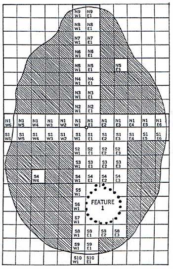
from which the grid is mapped out. If you look at Figure 1,
the red dot in the center is the datum point located on the
map. All squares around that point are labeled according to
the datum point. If you look closely, you can see how to properly
label the names for each square, also known as an excavation. Gridding
your archaeological site can be a complicated task. What may
seem easy at first, can soon become difficult. There are certain
steps to be taken in order to grid a site. The size, measurements,
and terrain of the site are the information needed to make gridding
a site less complicated. In order to begin the gridding of an
archaeological site, you need to do quite a few things. You
must start by choosing your datum point, serving as the basis
from which the grid is mapped out. If you look at Figure 1,
the red dot in the center is the datum point located on the
map. All squares around that point are labeled according to
the datum point. If you look closely, you can see how to properly
label the names for each square, also known as an excavation.
The next part is setting up the actual grid.
The best terrranean would be a flat, soil filled area. Measuring
tape will be needed, wood or metal stakes, as well as string
or wire. To grid the total area after making simple measurements
will ensure that all the squares will end up almost equal in
size. After this step has been completed, the grid must be drawn
on paper, complete with pictures of the steps throughout the
excavation process. When doing so, carefully label your datum
point, each excavation, and a compass determining which way
is north. This process will provide critical information while
excavating.
There is a simple process for labeling the
excavation. Locate the datum point on your grid. Hold the map
out so that North is pointing toward the North. Now for each
square North of the datum point and going Eastward, label boxes
in that direction N?E?. To the southeast right label them S?E?.
Replace each question mark according to the squares' location.
For example: If a box is to the south 3 and 4 to the east from
the datum point you would label it S3-E4. If further help is
needed Figure 1 will be of assistance.
The final part of the site is to keep it
up to date. The map should be duplicated in case of any lost
information. Any duplicates should be updated along with the
original. The site map will help to keep track of squares, which
excavations have been completed or started already, and which
squares are fresh. Taking occasional pictures gives a better
look at the grid. Some examples from an archaeological dig can
be viewed at www.reedfarmstead.com
Excavating an Archaeological Site
The most important part of an archaeological
dig is excavation. Excavation is the archaeologists main method
of attaining data to analyze. The process of excavation is not
easy. There are certain steps as well as methods that need to
be followed. Weather also plays a role in excavation as it can
have a great effect on the dig itself. Excavation is where the
majority of artifacts are found and an archaeologist needs to
have the knowledge of how to deal with these artifacts. A large
number of tools are also a major part of the excavation process.
It is vital for an archaeologist to know these tools as well
as their uses.
An archeologist needs to be extremely attentive when conducted
a dig as a site can only be excavated once. If something is
missed, one can never go back to find it. If that was attempted
there would be no stratigraphy and all of the data would be
off. It is imperative that archaeologists follow certain methods
in order to excavate and record a site properly. The deeper
a person digs, the farther back in time he/she goes. Each
layer represents a certain period of time determined by what
is found in each increment. It is important that each square
is excavated in the same manner. However, squares can be excavated
in different kinds of stratigraphic levels. This means that
the archaeologist can either follow the natural layers of
the soil or determine a set depth for each unit. For example,
in a dig conducted at Beverly High School the team of excavators
dug in ten centimeter increments.
The first site excavated is usually not
found on the official digging site. It is found nearby and known
as the control pit. This pit is dug in order to learn the nature
of the soils and deposits in an undisturbed state. The control
pit helps to determine the type of stratigraphy that one could
encounter during a dig. After the control pit is dug and examined
the next step before digging is to lie out a grid on the site
using the squares of the grid as a guide while excavating. Each
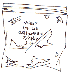
pit is excavated one at a time and all material found in the
pit is segregated according to the increment it was found in.
The gathered material found in specified increments during excavation
are placed in bags and labeled.
Excavation is not just digging and finding
artifacts. It is uncovering a culture and for that reason it
must not be hurried and all methods and procedures must be followed
carefully. During excavation it is important that the archaeologist
is not only focusing on the ground which he/she digs but also
why these certain artifacts are there. Making connections is
also part of excavation. All the information about context is
preserved through careful excavation and by fully documenting
artifacts with measurements, maps, and photographs. These tools
will help with uncovering the contextual data of an artifact.
Weather can have a huge effect on the excavation
process. An ideal excavation site is a moderately sunny area
with light evening showers in order to keep the site moist and
workable. Hot climates are not favored, as the site would be
difficult to dig, as the entire site would be dried up. However,
wet weather is also not an ideal situation as large amounts
of rainfall can damage the site and also makes it harder to
dig. When wet weather is expected it is important that the exposed
areas of the site are covered with a tarp in order to protect
the pit.
While digging, most people expect to find
things such as sherds of pottery, stone and other prehistoric
artifacts. These are all important to the excavation process
but other artifacts that one needs to be on the lookout for
are other materials such as pollen, plant parts, human and animal
bone, shell, and textiles. Pollen and seeds are extremely important
because after being tested the results can help determine climatic
or even economic changes.
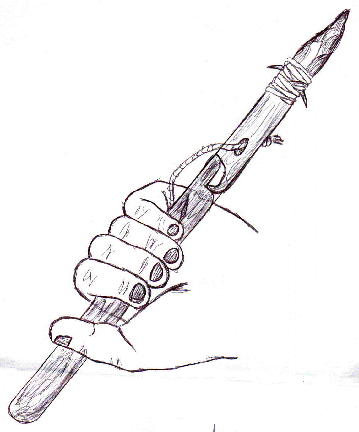
 There are many different tools used during the process of excavation.
Excavation can be done by hand or with heavy machinery. The
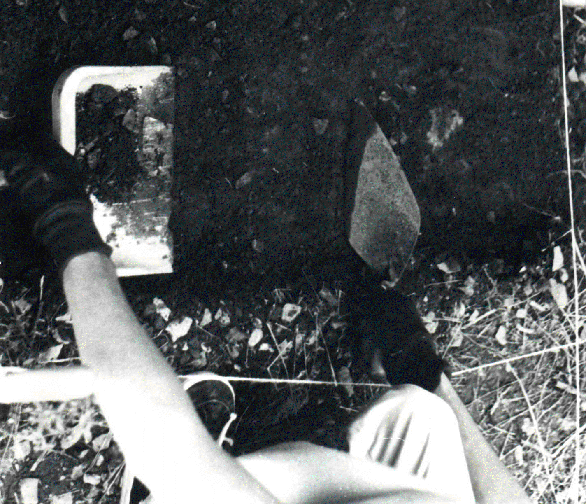
example used in this text however used only hand tools. A trowel
is used most often in excavation. It is used to slowly scrape
away the dirt of a site with the side of a trowel blade. The
blade must be kept at a ninety degree angle at all times and
should be used to take the dirt of a site away evenly. Also,
the point of the trowel should never be used. By using a trowel
artifacts tend to show up clearly if the trowel is used properly
the surface is usually flat and smooth. Another important tool
is a camera. Cameras are used in order to take pictures of both
the site as well as the artifacts. Pictures are extremely important
to the excavation processes. Many pictures should be taken throughout
the entire dig. Measurements are also extremely important. Because
of that a ruler and line level are two more tools needed during
the excavation process. The excavator needs to make sure that
he has not traveled outside of his increment during the dig
and so must use both the line level and ruler to check his depth
often. Another tool is a bucket. The bucket has two uses. One
use is to carry soil from the screening area to the site and
the other is to hold water. The water is then used to put the
trowel in. All seeds and pollen on the trowel will float. A
dustpan is a tool found most often on a site. It is used for
removing excavated soil with the help of the trowel. Brushes
are also used in order to clean soil away from artifacts.
There are many different tools used during the process of excavation.
Excavation can be done by hand or with heavy machinery. The
example used in this text however used only hand tools. A trowel
is used most often in excavation. It is used to slowly scrape
away the dirt of a site with the side of a trowel blade. The
blade must be kept at a ninety degree angle at all times and
should be used to take the dirt of a site away evenly. Also,
the point of the trowel should never be used. By using a trowel
artifacts tend to show up clearly if the trowel is used properly
the surface is usually flat and smooth. Another important tool
is a camera. Cameras are used in order to take pictures of both
the site as well as the artifacts. Pictures are extremely important
to the excavation processes. Many pictures should be taken throughout
the entire dig. Measurements are also extremely important. Because
of that a ruler and line level are two more tools needed during
the excavation process. The excavator needs to make sure that
he has not traveled outside of his increment during the dig
and so must use both the line level and ruler to check his depth
often. Another tool is a bucket. The bucket has two uses. One
use is to carry soil from the screening area to the site and
the other is to hold water. The water is then used to put the
trowel in. All seeds and pollen on the trowel will float. A
dustpan is a tool found most often on a site. It is used for
removing excavated soil with the help of the trowel. Brushes
are also used in order to clean soil away from artifacts.
After the soil is removed it is sifted through
mesh screens in order to recover the extremely small artifacts.
Another important tool is a magnet. A magnet can be run above
artifacts that are dirty in order to discover if they are magnetic.
Tinfoil is yet another imperative tool in the excavation process.
When an archaeologist finds anything with carbon on it (burnt
firewood) he/she should not touch it. Instead they should wrap
it in tinfoil and send it off for a carbon-14 dating test. Some
sites will also use bathroom tissue as a tool. This is sometimes
used to wrap bones in which will retain the moisture of the
bone until it arrives at the lab. The tissue will also prevent
disintegration.
It has been mentioned many times that an
archeologist must follow certain steps during excavation. A
few things that an excavator should never do is stand on the
edge of a square that is being excavated. This could cause the
square to cave in giving the archaeologist "scrambled eggs"
a site with no stratigraphy. A person should also never touch
carbon. If carbon is touched it will put current year fingerprints
on the artifact. This is why tinfoil is used. To preserve the
carbon. Another mistake that should never be made is mistakes
with the line level and ruler. If the site is measured incorrectly
all measurements will be off ruining all data.
A few points that should be remembered by an excavator
are after each increment he/she should keep an eye out for a
stratum change. Also, after each increment, take pictures. In
the pictures the trowel should always be pointing towards the
datum point. Also, it is important to secure the site with boards,
tarp, plastic etc to protect stratigraphy and soil level. One
more thing that should be remembered is if an artifact is sticking
out of the walls of a site the soil underneath the artifact
should not be touched. This could cause the walls to collapse
and ruin stratigraphy. When the tools are used correctly, and
methods of excavation are followed carefully excavation is a
useful tool for digging into the past and uncovering cultures
from past times.
Bones
Human and animal remains can tell us more
about the past than almost any artifact. Bones are the most
undeviating evidence we have with concern to human populations.
Studying human remains can teach us about ancient burial practices,
diseases and injuries of long ago, and about ancient DNA.A discovered
skeleton can uncover the diet of the people of that era.
Nutrition may potentially influence skeletal
form. By studying the teeth of a human skeleton can uncover
the types of food eaten, whether it was meat or vegetation.
A skeletons bone density, height and probable weight can also
reveal their ancient diet.
To differentiate the bones of different species
one should note different characteristics of the discovered
items. For instance if a large thick bone is discovered to be
crushed and broken apart chances are the bone belongs to that
of a cow or other large animal whose meat was consumed by humans.
The meat was probably smashed or cut then put in a stew to cook.
These remains would often be found in a garbage pit of an archaeological
site.Small thin bones found intact probably would belong to
that of a rabbit, chicken or turkey. These animals would be
prepared with the skeletal system ntact for the meat could be
eaten around the bones. However, chances are these bones would
not be found in close proximity together. They, too, would be
found in a garbage pit on the premise assorted with the remains
of other species.
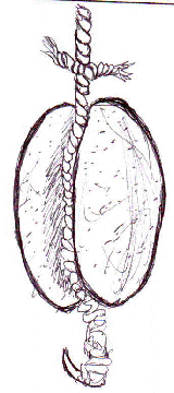
Cat bones, as seen in the provided image,
would show no signs of being part of a humans diet for they
were domestic pets. However, they very well would not be found
in a proper burial location but might be discovered in a garbage
pit. Large bones with rounded ends, or joints, found in a proper
burial spot almost certainly belong to a human being. Much can
be told be investigating a human remains. The beings diet, cause
of death, age, sex, and with today's technology their probable
facial appearance can all be determined.
Artifacts
Tools commonly found at a Site
They came from across an ocean to this rich,
new land. They brought with them what they could
carry on their backs. With no prior knowledge of what lay ahead,
they made use of what they found the animals, plants, water and
stones. The stones would prove to be the most useful gifts of
the land.
In the New England region the most abundant
resource were rocks, and the earliest Americans used them for
everything imagined. Projectile points were a very necessary part
for such tools as knives, spears, arrows and harpoons. They were
mainly made from flint. Many different sized and shaped rocks
were used in shaping the projectile point. After a good-sized
piece of flint was found, a rounded hammerstone was used to get
the basic shape. Antler, bone, or ivory was set on the flint and
hit with the hammerstone to chip away at the rock. Once the desired
shape and sharpness was achieved, the projectile point would be
tied onto the stick with sinew (tissue fibers); this method is
called hafting. To ensure that the point would not fall off a
notch would be made into the end of the stick and the point would
be fitted into that.
These tools were used both in fighting and
killing game. The most popular hunting tool at the time was probably
the spear. It could be thrown great distances and penetrated the
hide easily. As faster moving animals were being targeted, the
accuracy and distance of the spear had to be improved. This was
made possible by a new device called an Atlatl. The Atlatl was
basically a medium-length handle on which the end of the spear
was placed.
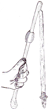  (atlatl
and spear) (atlatl
and spear)
Sometimes a weight was put on it to give more
power. The spear was launched from the Atlatl allowing improved
hunting skills.
Cutting tools were constructed and used by
the females. They were needed for preparing meals, and making
clothes. The Ulu knife could be used for both of these purposes.
First a hammerstone was used to accomplish the half circle shape.
In order to chisel off the bumps she used a palm-sized stone with
a semi-sharp point was used. Then the half-circle shape would
be grinded and polished with a smoother stone. The blade of the
Ulu knife was placed between two sanded sticks, which were bound
at the ends.
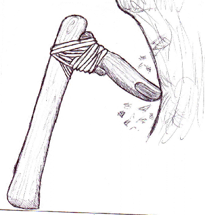
A channeled gouge was used in cutting down
trees to make canoes. The bottom of a tree was burned part way,
and then a channeled gouge would finish the job of chopping down
the tree. The channeled gouge was a thick branch with a small
knob about two inches from the end. A wedge-shaped stone with
a partial handle was tied to the end and the knob with sinew.
As tribes migrated from different areas, new
customs were introduced to the native tribes. One new idea to
come to New England was pipe smoking. There were three main shapes
for pipes then, Platform, Straight and Elbow. They were made of
a type of stone called Steatite. Spinning a stick between the
hands, eventually drilling into the pipe made the hole.
As time passed the tools became more varied.
For example, their drills could be found in many sizes. They were
made almost the same way as knife and spearheads though they were
smaller and thinner. Some different types were plain, t-base,
tapered stem, eared, cross, diamond, and pipe bowl reamer. These
not only differed in size but also in the shape of the base of
the point and how it would be attached to a piece of wood.
Early fishing can be associated with modern
day fishing with the ideas of harpoons and sinkers. The harpoons
were not much different than they are now. They were composed
of a projectile point hafted to a thick branch, which had a hole
in it. Through the hole a rope was strung which ran to another
branch, which the first was bound to with a breakable string.
This allowed the harpoon head to come loose when it penetrated
the fish. The fisherman would then pull it in by the rope and
remove the harpoon head. Sinkers or Classic Plummets were heavy,
oval shaped stones with a small knob on top to be tied to. They
were very symmetrical for such primitive tools. The common stones
for sinkers were sandstone and granite. A hook was sometimes hung
from it to serve as a lure.
The evolution of the fishing ways changed,
as did the tools. As time passed the harpoons were still in use
and did not change too much besides now being made from antler
or bone. The sinkers became larger and a little less care was
put into making them. A new technology however was the fish weir.
The fish weir was a large series of fences which were strategically
placed so that fish could swim in but not out. The women now were
smoking and drying the fish, which called for the production of
drying racks.
Most of the archaeology in this area focuses
on stone and bone artifacts. This is because the soil in New England
does not favor wood and causes it to rot very quickly. Also, the
natives new that wood was not very hard so the most important
parts of their tools had to be made out of stone. Bone was useful
but not as much as the abundant rock.
- Paleo-Indian tools- The Paleo-Indians came to New England
in 8500 B.C. and stayed until 5000 B.C. The most well known
projectile is the spear point; other well-known tools are the
scrapers and knives.
- Fluted spear points- these are considered the paleo hallmark.
The spear points were made out of imported flint from New York.
- Large stem scraper- This was used to remove the hair from
the hides of the animal so that clothes and other hide products
could be made.
- Paleo Knife- Archaeologists believe that this is the most
important tool next to the spear. It had a variety of uses from
the cutting of animals they had just killed to the making of
their new tools.
Early Archaic Indians
The early archaic Indians were around in 5000bc
to 3000 B.C. The changed New England brought new animals and new
plants along with the new Native Americans. These Indians lived
basically on caribou instead of mammoth and masterdon as its predecessors
did probably their biggest breakthrough was the atlatl. An atlatl
is made from bone hook, stone weight and a straight stick. The
atlatl gave the thrower greater velocity and therefore greater
distance seeing how the caribou were faster and more skittish
then mammoths they did not need to get scared and ran away.
In fishing there was another major breakthrough
for the Indians. The Early Archaic Indians developed harpoons
and plummets. Harpoons were made with a long wooden shaft with
a break off point that was attached to a rope. The break off point
had barbs to keep it in the larger fish and water mammals. After
it was stabbed with the newest harpoon it could be easily hauled
in with the attached rope.
Plummet- It was a small stone with a notched
end to attach the string to and two small bone hooks attached
to the other end. The stone was used as a sinker and was rubbed
with some kind of bait to attract the fish
 - Plummet - Plummet
The Early archaic Indians also made advances
in the cutting tools, mostly knives. Now the knives had wooden
handles and were made out of different stones that were smooth
but maintained a sharper and keener edge. There were also new
woodworking tools to make it easier to build canoes. The canoes
were made from oak trees that the base of the tree was burned
so that the tree fell. They then burned the side of the tree to
make the tree hollow. They then hollowed out the charred wood.
Late Archaic Indian
The late archaic Indians made many new advances
in everything from old woodworking tools to developing new ways
of fishing. They also learned how to make stone bowls and pipes
using a new material that was being imported from the Superior
Lake region. The late archaic Indians were in New England from
3000 B.C. to 300A.D.
Stone bowls
Stone bowls were made from Soapstone, a recent
discovery. It was now possible to store liquids such as water,
and cook foods such as stews that were previously impossible to
cook. The bowls were made using a variety of new tools that had
been adapted especially fro the making of stone bowls. They developed
abrading stones, for smoothing out the bowls, triangle tailings
and spade for mining the soapstone deposits.
Copper was found in the lake superior region.
Before it was of no use because copper was brittle when cold and
could not be shaped to make any use of. After the discovery that
copper was malleable when heated over fire many old tools were
now made out of copper such as axes and gouges for woodworking.
The Late Archaic Indians also developed fishing
weirs that were made by using posts made out of saplings, and
a net of woven reeds between the posts. The weir let the fish
in during high tide and trapped the fish during low tide. At low
tide they could just walk and grab the fish with their hands.
Ceramics woodland Indians: These were the
Native Americans that old world explorers traveling to the New
England. They were in this region from 300ad al the way up to
1676 ad. These new Indians were no longer nomadic and were finally
settling down forming small villages. The Indians were now becoming
agriculturally based and there for new tools had to be made for
farming. They also made several advances in pottery.
They needed to clear fields for planting crops
and they did this by burning the base of the tree out so that
the tree was still usable for canoes and other tools. Then they
used the new popular groove less axes that were also used as weapons.
New tools were also developed for breaking apart the ground. The
triangle hoe was made out of one piece of rock shaped triangularly;
it was lashed on to a long pole.
Pottery
Some of the most interesting finds today in
archeology are the pottery artifacts. The three categories of
pottery in the Anglo-American colonial world are earthenware,
stoneware, and porcelain.
Earthenware is a water absorbent stone, which
by putting glaze on makes it impermeable. Glaze that was used
for earthenware was usually composed of lead sulfide, and it adds
color to it. Normally pure lead is colorless and is transparent.
Its firing point in the kiln is the lowest of all. When working
on an archaeological site the most common objects found are earthenware.
Stoneware has a higher firing point than earthenware.
It has hardness to it and is not a water absorbent material. Therefore
it doesnt need glaze on it but a salt glaze is often used. This
gives it a smooth, easy to clean, glassy look.
Porcelain is made out of special clay called
Kaolin. It is hard, translucent, and impermeable to water. It
also has the highest firing point. Slip is decoration on the pottery
that is made by white pipe clay, applied in liquid form, underneath
the glaze; in the way you would decorate a cake. Other ways of
decoration was using a rocker stamp, which is a shell. The edge
of the shell was rocked back and forth, to produce a zigzag design.
They also used sharp pointed rocks to make lines.
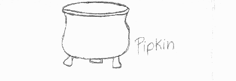
Pipkins are small, three legged cooking pots,
made of earthenware glazed in green or yellow. The second period
New England plates have come to be mostly of delftware and were
large and elaborate. Delftware has a soft body and thick white
glaze that covers it. It is painted with either blue or polychrome
designs. Ceramic cups and mugs are very common after 1660.
The steps they used in making their pottery are the following:
- The first step in pottery making is the clay digging and
powdering the clay.
- The second part is adding water and the tempering of crushed
stones and shells.
- Third step is rolling out the clay into a coil shape, and
also make a small base.
- Fourth step is to take the coiled shaped clay, and work it
around the base to build up the sides. After that is done, take
a wooden paddle and smooth up the outer and inner wall.
- The final step is to place the finished product in an open
flame and allow it to cool down.
|
Type of pottery
|
Firing Point
|
|
Earthenware
|
1292 degrees F
|
|
Stoneware
|
2102 degrees F
|
|
Porcelain
|
2552 degrees F
|
|
Type of Glaze
|
Mineral Used
|
Color
|
|
Blue Stains----------------------------------
|
Cobalt
|
Blue
|
|
|
Alumina
|
Pale Blue
|
| |
Chrome - Cobalt
|
Blue - Green
|
| |
Vanadium
|
Turquoise
|
| |
Copper
|
Blue
|
|
Green Stains--------------------------------
|
Chrome
|
Olive Green
|
| |
Vanadium - Copper
|
Green
|
|
Red, Orange, Yellow Stains------------
|
Cadium - Selemium
|
Red Orange
|
|
Yellow Stains-------------------------------
|
Antimony - Lead, Zinc Base
|
Naples Yellow
|
| |
Lead Chromate
|
Yellow
|
| |
Tin - Vanadium
|
Lemons, Mustard
|
| |
Praseodyminm
|
Yellow Orange
|
| |
Vanadium - Zinconim
|
Yellow
|
|
Maroon Stains-----------------------------
|
Chrome - Tin
|
Maroons and Blue - Pinks
|
| |
Magnase
|
Maroons and Pinks
|
|
Peach Stains--------------------------------
|
Chrome - Tin Use Tinopacifer
|
Pinks
|
| |
Maganese
|
Pink, Violets
|
| |
Chrome - Alumina
|
Pinks
|
|
Brown Stains-------------------------------
|
Iron
|
Red Brown
|
| |
Chrome, Alumina, Zinc
|
Tan
|
|
Black Stains--------------------------------
|
Iron Blacks
|
Brownish Black
|
| |
Cobalt Blacks
|
Blue - Black
|
| |
Cobalt - Chrome Blacks
|
Greenish Black
|
| |
Cobalt - Free Blacks
|
Usually Gray Black
|
Research (Dating)
Radiocarbon Dating
Radiocarbon dating is the process in which
the carbon-14 content of a fossil or artifact is measured to determine
the how old the artifact is. Comparing the amount of carbon-14
to the amount of carbon-12 in the artifact in order to determine
how much carbon-14 has disintegrated since it had last been exposed
to any organic material from a living organism does this. This
method can place a relatively accurate age on objects dating back
60,000 to 70,000 years. In the case of a fossil, the carbon-14
decay is referred back to when the organism had died. Death causes
the metabolic system to cease, thus stopping the intake of carbon
into the body. Carbon-14 is an unstable atom and therefore signs
of disintegration appear, while carbon-12 is a stable atom and
shows no signs of decay. All organic material contains carbon-14,
an element produced by cosmic rays from space. The origin of these
rays is not yet fully understood.
Willard F. Libby discovered the method of
Radiocarbon Dating in 1949. He had many theories about the isotope
carbon-14s role in metabolism of living organisms. When he found
that measuring the radioactive decay of an organism could date
organic material, his discovery immediately caused a serious commotion.
Radiocarbon Dating was popularized as the clock that runs backwards
Many archaeologists stood by Libbys discovery, such as Glyn Daniel,
who described it as Perhaps the greatest breakthrough in the
development of archaeology6
Yet others in the archaeological field felt
that radiocarbon dating was unreliable, because it was registering
dates that were thousands of years off what they had hypothesized.
This was because many archaeologists were making simple mistakes
in the excavation of these items. One of the problems with radiocarbon
dating is that an error can occur in dating an artifact if the
object comes in contact with any organic material, which is most
commonly contact with human skin. This erases the original date,
when it last came in contact with carbon-14 thousands of years
ago, and replaces it with an age of zero. This mistake can also
be made if a tool that has not been properly cleaned or is made
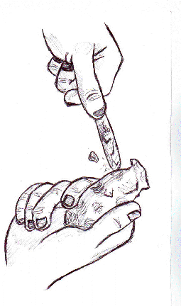
out of wood touches the object. The correct way to handle an artifact
that is intended for radiocarbon dating is picking it up with
aluminum foil and storing it inside some sort of clean, metal
container.
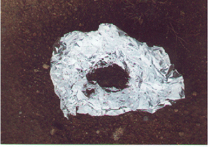 - ( artifact containing
carbon placed in tin foil) - ( artifact containing
carbon placed in tin foil)
Although radiocarbon dating has made many advances
since it has been introduced in the mid 1900s, there is still
a great amount of controversy directed at its reliability in dating
archaeological discoveries. Recently, Radiocarbon Dating has become
a key factor in the sensitive issue of religion. In 1988, The
Shroud of Turin was sent to a laboratory to undergo radiocarbon
dating, in order to reveal its true age. The Shroud of Turin
is the piece of cloth believed to be what Jesus wore during his
final days on earth. Followers of the Christian faith have valued
the Shroud as a symbol of Jesuss death and resurrection. But
when the Shroud was tested, the carbon-14 in the linen of the
cloth was dated no later than the Middle Ages. This drove many
devoted Christians to believe that the radiocarbon dating was
not a valid method for accurate dating, therefore widening the
gap between the church and science. Other speculators of the Christian
faith suggested that the cloth may have been tampered with in
the Middle Ages, and that there is still a possibility Christ
could have worn it. Either way, it is certain that radiocarbon
dating has made its mark on society.
Potassium Argon Dating
Potassium Argon dating bears great resemblance
to that of Radiocarbon Dating. Using the same basic method of
measuring, the decay of an unstable isotope is found on an artifact.
The big difference between these two methods is that the half-life
of potassium-40, the isotope used in Potassium Argon dating, is
significantly longer than that of carbon-14; ranging somewhere
around a thousand million years. An untouched sample of potassium-40
can date an object back to the beginning of mankind, when the
earth was still in the early stages of its existence. Potassium
is a much more abundant element on earth as well; it is found
in nearly every mineral inhabiting the earths surface and crust.
When a potassium-40 disintegrates, it either
turns into calcium-40 or argon-40. Argon-40, also an isotope with
an exceptionally long half-life, builds up in minerals along with
potassium. The proportionof potassium-40 to argon-40 can be measured
to reveal the age of the artifact it inhabits. Since all organic
materials are not potassium-based, potassium argon dating allows
for less error in the laboratory or archaeological site. An archaeologist
must be careful as to not contaminate the sample with argon build
up in the earths atmosphere, where it is most commonly found.
Also, there is a limited amount of minerals that can be used for
this dating system, because of different argon isotopes that may
be present in the object being dated. This method of dating, although
quite difficult to perform due to its limitations, has become
a great asset to archaeologists looking to delve deeper into prehistoric
civilizations.
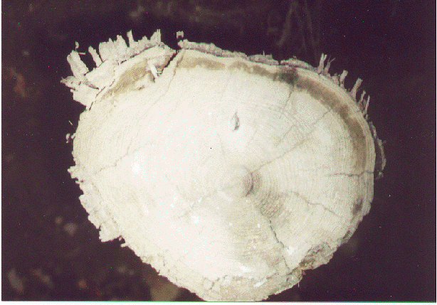
Dendrochronology
Dendrochronology is a method of dating that
involves counting and measuring the rings of a tree to determine
its age, and the history of the climate where the tree was living.
The basic elements of this method have been around for hundreds
of years, but it wasnt closely examined until the late 1800s.
Andrew Ellicott Douglass, an astronomer at the Harvard College
Observatory, adopted this study in 1894, while the Lowell Observatory
in Flagstaff, Arizona, observing sunspots. In his experiments,
he needed information about the climate in Arizona in the past
hundred or so years. Mr. Douglass thought that tree rings might
hold some of the clues he needed. By examining many different
samples in the area around Flagstaff, he managed to amass considerable
amounts of information on the history of the climate in that area.
This led Douglass to pursue a great interest in tree rings, a
field he was now pioneering.
Trees acquire a new ring every year. In the
spring a tree develops a layer of large cells underneath the bark
known as cabrium. By winter, the cells die, harden, and become
wood. This process is repeated every year of the trees life.
By examining the trees rings, one can tell what sort of climate
the tree was exposed to the year that ring was formed. If the
ring is thick, that means that it was a good year for growth,
with healthy amounts of sun and rain. If the ring is thin, then
the year may have seen a drought, or temperatures may have been
colder than usual. Since trees near each other have the same tree
ring patterns, you can compare a tree that you know the age of
to a tree you do not know the age of by matching up patterns (See
figure 1). This method has allowed dendrochronologists to date
trees as far back as 59 B.C.
( Below is what the rings of a tree look like that Dendrochronologists
study to dtermine diffrent weather patterns in a particular area)
Figure 1:
Pipestem Dating
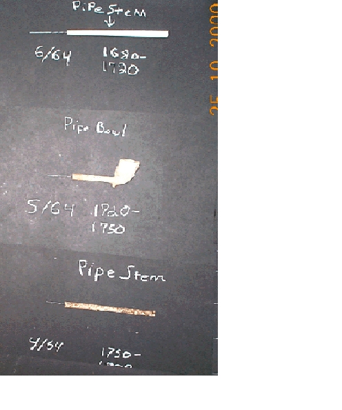
|
Diameter
|
Dates
|
|
9/64
|
1590-1620
|
|
8/64
|
1620-1650
|
|
7/64
|
1650-1680
|
|
6/64
|
1680-1720
|
|
5/64
|
1720-1750
|
|
4/64
|
1750-1800
|
During the mid 1500s, pipe smoking became
very popular in England. Although there was a limited supply of
tobacco available at the time, clay pipes were inexpensive to
make and therefore nearly anyone could afford to buy them. People
disposed of their clay pipes after using them only a few times;
this is why so many English kaolin pipe fragments are unearthed
at archaeological excavations. These pipes were brought to America
to be traded to Indians and colonies. This is why archaeological
sites in the New England area usually contain thousands of kaolin
pipe fragments.
With tobacco becoming more accessible, the
bowl of the pipe became larger and the stem became longer. As
technology in pipe manufacturing progressed, pipe makers found
ways to make the hole in the stem smaller, allowing for less tobacco
to go unburned. They did this by using a smaller bore to drill
a hole in the stem. These are the bore sizes along with the time
in which they were used:
Archaeologists have developed tools to measure
the diameter of these holes. Edward J. Lenkin, an archaeologist
from New Jersey, developed a tool called the "step gauge", a steel
rod that accommodates all six sizes. The instrument is pushed
into the bore until it cannot go any farther, and then a measurement
on the side of the rod tells the diameter of the hole.
Palynology
Archaeological finds involving human remains
have been most successful when the body is found in a marsh or
a swamp, because chemicals in the bog water are able to preserve
organic material for thousands of years. But a human corpse is
not the only useful thing an archaeologist can find in a bog.
Pollen grains from plants and trees can be preserved in bogs for
many years and still maintain their original form and size. This
allows archaeologists to understand what sort of plant life was
growing during the period when the layer of bog they were studying
was at the surface of the marsh.
Lennart van Post, a Swedish archaeologist
discovered this method of dating in the early 1900s. He found
that if pollen were laid down on regular ground, it would decompose
and be destroyed by microorganisms, or by chemical weathering.
But if it is laid in a bog, the pollen does not decay and becomes
somewhat of a fossil. This preserved fossil not only tells the
history of the vegetation in that area, but also of the past
climatic changes the environment has undergone. Patterns in
vegetation that create a path along land may be a clue as to
the migration patterns of certain animals or people who depend
on that plant to survive. Thus, what seems to be a simple grain
of pollen in a swamp may hold implications to the activities
of prehistoric packs of animals and human societies.
Stratigraphy
Relative dating does not give archaeologists
an actual date of an artifact. It is used to get a general idea
of an artifacts age compared to other artifacts found in a site.
Archaeologists can create a sequence of events by using relative
dating.
Stratigraphy is a method of relative dating.
It is the study of the layers of an archaeological pit. The deeper
a layer is in the site, the older it is. Objects that are found
at or near the top of the site are newer than those below it.
Changes in soil throughout the pit allow archaeologists to easily
form a sequence of events. They simply excavate and study one
layer at a time, with all artifacts from that layer coming from
approximately the same time period. If distinct layers cannot
be seen in the soil of a pit, things can become difficult. The
archaeologist is forced to rely on using levels of 1 to 10 centimeters.
This may or may not produce accurate results.
There are several factors that can throw off
the method of stratigraphy. Animals such as gophers, who dig in
the ground, can disturb the soil. If a large hole had been dug
on or near the site previously for a house foundation, soil may
have been taken from the hole and deposited nearby. This causes
deeper layers, which are the oldest, to settle near the top causing
the archaeologist to believe they are the most recent, while excavating
a site. Archaeologists are able to determine when this occurs
by comparing their results to other excavations in the area.
Seriation
Seriation is another type of relative dating.
It is the study of artifacts popularity. It is typically done
when there is no stratigraphy present in a site. While studying
seriation an archaeologist looks at when an artifact was first
introduced, when it reaches its peak in popularity, when the popularity
declines, and when the artifact dies out completely. When population
patterns are graphed they produce a battleship shaped curve. The
bars start off narrow, grow wider and then they become narrow
again. Some artifacts produce a pattern that lasts thousands of
years while others only last a few weeks.
By using seriation, archaeologists can learn
a lot of information about an archaeological site and other sites
nearby. Seriation cannot determine the exact time period of an
artifact or site or its length of use. It cannot tell archaeologists
which artifacts or sites came earlier or later. It can only find
its relative date.
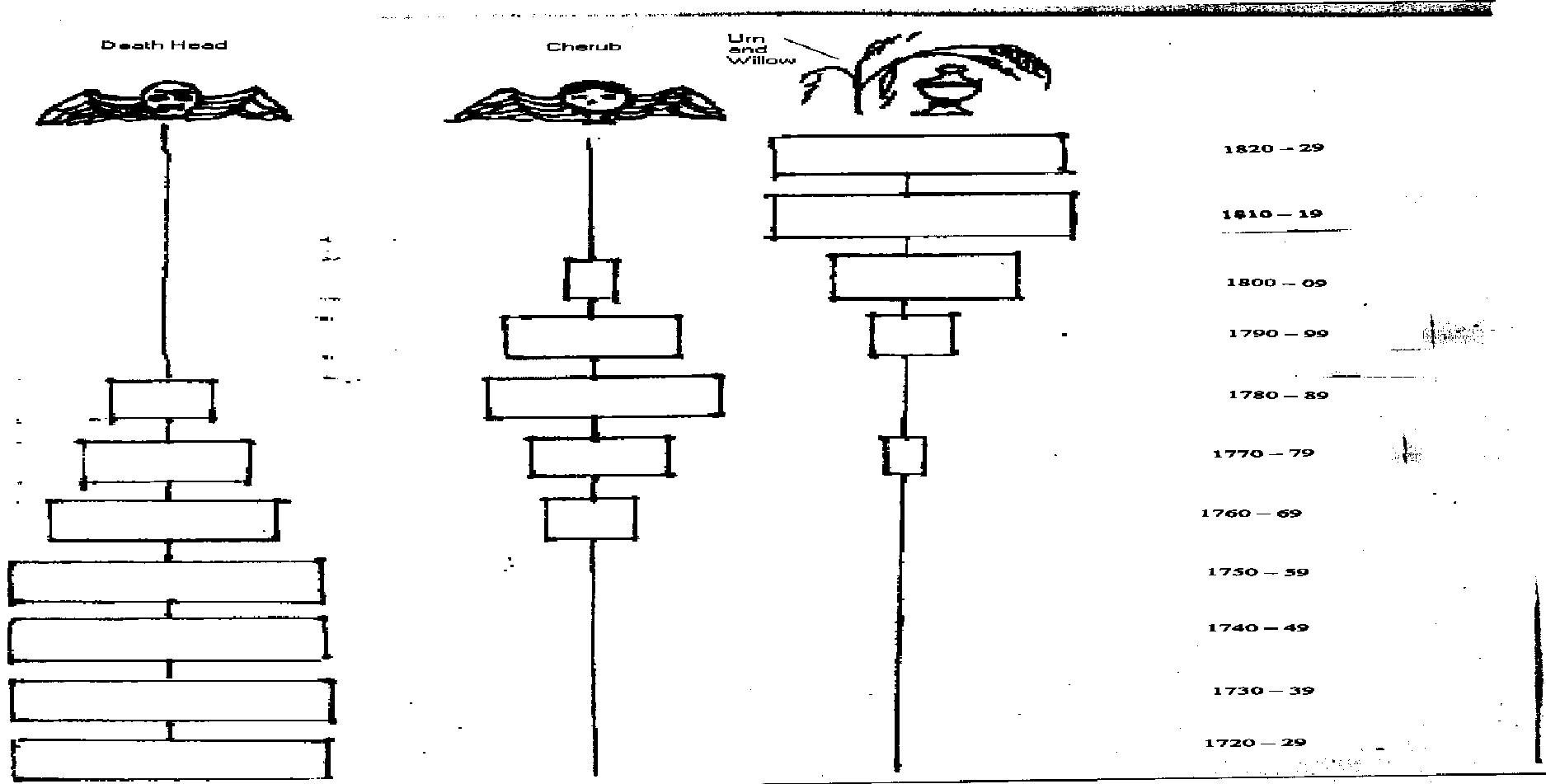
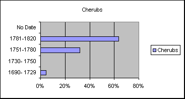
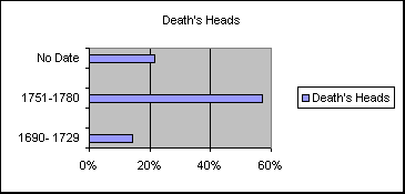
Deetz did a seriation study in the 1960s.
He studied three different styles of gravestones in New England
cemeteries. The three designs were the death head, the cherub
and the urn and willow. Gravestones are dated, so Deetz was easily
able to have an accurate study. In his study he found that the
death heads came about first, followed by the cherub, and then
the urn and willow became the prevalent design. He found this
pattern overwhelmingly present in hundreds of New England cemeteries.
When his data was put into a bar graph it formed a near perfect
battleship curve.
Archaeology Is a complex and highly intellectual
science. Through Archaeology we satisfy curiosity and thirst for
knowledge. Archaeology presents many answered questions and more
questions in the end then before that site was started. It helps
us to figure out where weve been, and there for since history
tends to repeat it shows us our path into the future. Archaeology
ties nations together and breaks them apart ( I.e. The pyramids
in egypt started many conflicts over countries breaking in to
them and looting them). Mans interest in archaeology is for ever
expanding and will never be quenched.
(Below: Chart based on finial and border data.)
| URN &
WILLOW |
|
|
|
|
|
| |
|
|
|
|
|
| (Borders) |
|
|
|
|
|
| |
1690- 1729 |
1730- 1750 |
1751-1780 |
1781-1820 |
No Date |
| |
|
|
|
|
|
| Acanthus |
0
|
0
|
1
|
0
|
0
|
| Fig |
0
|
0
|
0
|
0
|
0
|
| Grapevine |
0
|
0
|
0
|
0
|
0
|
| Pumpkin |
0
|
0
|
0
|
0
|
0
|
| Columns |
0
|
0
|
2
|
0
|
0
|
| Scroll |
0
|
0
|
0
|
0
|
0
|
| Bedpost |
0
|
0
|
0
|
12
|
0
|
| None |
1
|
0
|
1
|
23
|
0
|
| Other |
1
|
0
|
0
|
2
|
0
|
| |
|
|
|
|
|
| |
|
|
|
|
|
| (Finials) |
|
|
|
|
|
| |
1690- 1729 |
1730- 1750 |
1751-1780 |
1781-1820 |
No Date |
| |
|
|
|
|
|
| Whorl |
0
|
0
|
0
|
1
|
0
|
| Banded Whorl |
0
|
0
|
0
|
0
|
0
|
| Concentric |
0
|
0
|
0
|
0
|
0
|
| Banded Disc |
0
|
0
|
0
|
0
|
0
|
| Tiny Head |
0
|
0
|
0
|
0
|
0
|
| Pie |
0
|
0
|
0
|
0
|
0
|
| Webbed |
0
|
0
|
0
|
0
|
0
|
| 5 Petaled Rosette |
0
|
0
|
0
|
1
|
0
|
| Diamond |
0
|
0
|
0
|
0
|
0
|
| Vine |
0
|
0
|
0
|
0
|
0
|
| Bedpost |
0
|
0
|
0
|
3
|
0
|
| None |
0
|
0
|
0
|
37
|
0
|
| Other |
0
|
0
|
0
|
1
|
0
|
| |
|
|
|
|
|
| |
|
|
|
|
|
| (Inscriptions) |
|
|
|
|
|
| |
1690- 1729 |
1730- 1750 |
1751-1780 |
1781-1820 |
No Date |
| |
|
|
|
|
|
| Here Lies |
0
|
0
|
0
|
1
|
0
|
| In Memory |
0
|
0
|
0
|
14
|
0
|
| Erected in Memory |
0
|
0
|
0
|
0
|
0
|
| Departed this Life |
0
|
0
|
0
|
1
|
0
|
| Sacred to the Memory of |
0
|
0
|
0
|
10
|
0
|
| None |
0
|
0
|
0
|
17
|
0
|
Works Cited
Relative Chronology. "Timing is Everything" [http://archaeology.about.com/science/archaeology/library.../aa010498]
8 Oct. 2000
Ceramics Unique. Information Technology & Consulting (ITaC)
1996
http://www.dnaco.net/~ceramics/index.html
Neefe, Jim. Pottery Making. Stapleton, 1997. http://www.madison.K12.wi.us/whitehorse/ss/potmake.html
Deetz, James. In Small Things Forgotten: An Archaeology
of Early American Life. Anchor Books, New York, 1977.
Eastman, Dean. Archaeology Workbook/Handbook.
Why do archaeologists excavate? [http.//www.paintedturtle.net/archaeology/excavate.html]
Archaeology. http://web.lemoyne.edu/~begiral/frtools.html
Archaeological Excavation. http://www.statemuseum.arizone.edu/arch/arcexcav.html
McIntosh, Jane. The Practical Archaeologist. New York:
Checkmark Books,1999.
Samford, Patrica, and D. Ribblet. Archaeology for Young
Explorers. Williamsburg Foundation, 1995.
Shephard, Steven. A Field Manuel for Alexandria Archaeology.
Alexandria Papers in Urban Archaeology Education Series, Number
4, 1981.
Rahtz, Philip. Invitation to Archaeology. New
York: Basil Blackwell Inc., 1985.
Ceramics Unique Information Technology & Consulting (ITaC)
1996 [http://www.dnaco.net/~ceramics/index.html]
Neefe, Jim. Pottery Making.Ben Stapleton, 1997. [http://www.madison.K12.wi.us/whitehorse/ss/potmake.html]
|